
The Edwards Aquifer is an intensely faulted and fractured carbonate limestone formation that lies within the Balcones fault zone. The storage capacity, flow characteristics, water producing capabilities and efficient recharging ability make this geologic anomaly one of the most wondrous aquifers in the nation. The San Antonio portion of the Edwards Aquifer extends approximately 180 miles from the Brackettville area in the west to Kyle in the east (see map below). The small hydraulic gradients and the large discharge volume at the springs and many high-capacity yielding wells demonstrate the immense transmissibility of the Edwards Aquifer. The recharge zone is its outcrop area in the Balcones fault zone. Average groundwater recharge to the Edwards Aquifer in the San Antonio area from 1934 through 1997 was 676,000 acre-feet annually (Walthour and others, 1997).
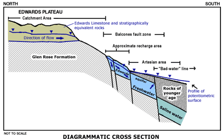 |
| Click here for a larger example of a diagrammatic cross section. |
In the San Antonio region, the Edwards Limestone attains a thickness of approximately 450 to 500 feet, of which about 450 feet make up the Edwards Aquifer. Other rock properties, which make up the Edwards limestone, but at lesser quantities, are: chert, dolomite and evaporites. The major lithostratigraphic units of the Edwards Aquifer are the Kainer, Person and Georgetown formations. (Maclay and Small, 1976). The Person and Kainer formation are subdivided into seven members. The Person formation members are the Cyclic and Marine member, Leached and Collapsed member, and the Regional Dense member. The Kainer formation members are the Grainstone, Kirschberg Evaporite, Dolomitic, and the Basal Nodular. (Rose, 1972). The porosity and permeability of the confined freshwater part of the Edwards Aquifer result primarily from the calcification of dolomitic rocks by circulating calcium rich groundwater. In the unconfined portion of the aquifer, the permeability is characterized by dissolution of limestone by circulating groundwater, which led to the development of a cavernous network along fractures associated with the Edwards formation (Maclay, 1995).
Regional flow of water within the aquifer is generally from west to east. (Fig. 1) Approximately 70 percent of the recharge into the Edwards Aquifer occurs in the western counties (Kinney, Uvalde and Medina). Barriers to flow on the southern edge of the artesian zone direct the flow toward the east.
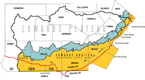 |
| Click here for a detailed figure of the hydrologic setting. |
The downdip boundary of the Edwards Aquifer is marked by the freshwater/saline-water interface. It divides the Edwards into the updip freshwater zone containing potable, or drinkable, water and the downdip saline-water zone with a concentration of total dissolved solids of greater than 1,000 mg/L (Schultz, 1992). This boundary is sometimes referred to as the “bad-water line.” Most of the meteoric water entering the aquifer from the recharge zone moves through the freshwater zone before being discharged. Low permeability in the saline-confined portion of the aquifer is attributed to limited interconnection between pores in the rock matrix and to the lack of substantial dissolution along fractures (Maclay, 1995). However, due to the hydraulic gradient declines toward the saline zone some of the freshwater moves into the saline zone.